 |
Bikini Atoll:
an Example |
The story of the Bikinians relocations is probably the most notable of
the Marchallese relocations as the people of the Bikini atoll have endured
several moves since 1946 and still have not completely returned to their
homeland. (Niedenthal, 2002)
The attitudes of the Bikinians toward these relocations are evident within
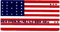
the description of their Flag's design.
- The close resemblance of the Bikinians flag to the flag of the United
States is to remind the people and the government of America that a
great debt is still owed by them to the people of Bikini. (Niedenthal,
2001)
- This debt is described in great detail in several documents located
at www.bikiniatoll.com especially
the petition to the US for payments to the Bikini people. Located at
http://www.bikiniatoll.com/petition.html
- Several quotes from Bikinians are represented
throughout these documents detailing some of the attitudes that they
have had toward these relocations.
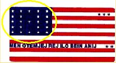
 The 23 white stars in the field of blue in the upper left hand corner
of the flag represent the islets that make up the Bikini Atoll. Although,
some sources credit the Bikini atoll as having a total of 36 different
islets (Spennemann, 2000).
 The
three black stars in the upper right of the flag represent the three
islands that were vaporized by the March 1, 1954, hydrogen bomb blast,
code named Bravo - 15 megaton yield. (Niedenthal, 2001) The
three black stars in the upper right of the flag represent the three
islands that were vaporized by the March 1, 1954, hydrogen bomb blast,
code named Bravo - 15 megaton yield. (Niedenthal, 2001)- These three islands were Bokonijien, Aerokokil, and Nam.
- The tale of relocations of the Bikinians can be found at http://www.hss.energy.gov/HealthSafety/IHS/marshall/marsh/
- I've also compiled several sources and created a timeline
of several relocations of the Marshallese peoples (specifically focusing
on the Bikinians)
 The
two black stars of the flag in the lower right hand corner represent
where the Bikinians live now, Kili Island, 425 miles to the south of
Bikini Atoll, and Ejit Island of the Majuro Atoll. The
two black stars of the flag in the lower right hand corner represent
where the Bikinians live now, Kili Island, 425 miles to the south of
Bikini Atoll, and Ejit Island of the Majuro Atoll. - These two stars are symbolically far away from Bikini's stars on the
flag as the islands are in real life (both in distance and quality of
life). (Niedenthal, 2002)
- The distance (about 425 miles to the south) and quality of life are
mentioned due to the fact that the Bikini Atoll had a total land area
of about 3 square miles vs. Kili Island with a total land area of 0.36
square miles. (Niedenthal, 2001) this decrease in land area forced a
decrease in quality of life. The Bikinians moved into crowded housing
with a diminishing food shortage.
 The
Marshallese words across the bottom of the flag, "MEN OTEMJEJ REJ
ILO BEIN ANIJ" [Translation: "Everything is in the hands of
God."], represent the words spoken in 1946 by the Bikinian leader,
Juda, in response to U.S. Commodore Ben Wyatt "when the American
went to Bikini to ask the islanders--on a Sunday after church--to give
up their islands 'For the good of mankind and to end all world wars'"
(Niedenthal, 2002) The
Marshallese words across the bottom of the flag, "MEN OTEMJEJ REJ
ILO BEIN ANIJ" [Translation: "Everything is in the hands of
God."], represent the words spoken in 1946 by the Bikinian leader,
Juda, in response to U.S. Commodore Ben Wyatt "when the American
went to Bikini to ask the islanders--on a Sunday after church--to give
up their islands 'For the good of mankind and to end all world wars'"
(Niedenthal, 2002)
- March 07, 1946: The U.S. Navy evacuates Bikini Atoll inhabitants to
Rongerik Atoll.
- March 14 1948: The Bikini evacuees are moved to a temporary camp on
the Kwajalein Navy base.
- November 2, 1948: The Navy moves the Bikini community of 184 people
to Kili.
- 1967: An anthropological study of the Bikinians and their leaders
reveals that most are dissatisfied with Kili and wish to return to Bikini.
- 1972: Three Bikini families move back to Bikini with approximately
50 Marshallese construction and maintenance workers.
- 1974: A group of Bikini people refuse to return to the atoll on May
25,1974 until they receive appropriate compensation for the past 25
years.
- 1978: Relocation of Bikini residents to Kili Island begins.
- 1990s: Tourism push throughout the Islands and infrastructure development,
continued cleanup.
- 1996: “The people of Bikini decided to open the atoll to divers
to provide an economic base for the possible future resettlement of
their homeland.” (Niedenthal, 2001)
- 1990s: The United States Congress provided $90 million to decontaminate
Bikini and establish plans for its repopulation.
|
 |
Project
Resources |
|
|
|

